Wikipedia
This text was copied from Wikipedia on 21 January 2025 at 4:10AM.
| Ward of Cornhill | |
|---|---|
 Location within the City | |
Location within Greater London | |
| OS grid reference | TQ327811 |
| Sui generis | |
| Administrative area | Greater London |
| Region | |
| Country | England |
| Sovereign state | United Kingdom |
| Post town | LONDON |
| Postcode district | EC3 |
| Dialling code | 020 |
| Police | City of London |
| Fire | London |
| Ambulance | London |
| UK Parliament | |
| London Assembly | |
Cornhill (formerly also Cornhil) is a ward and street in the City of London, the historic nucleus and financial centre of modern London, England. The street runs between Bank Junction and Leadenhall Street.
The hill from which it takes its name is one of the three ancient hills of London; the others are Tower Hill, site of the Tower of London, and Ludgate Hill, crowned by St Paul's Cathedral. The highest point of Cornhill is at 17.7 metres (58 ft) above sea level.[1]
History

Cornhill is one of the traditional divisions of the City. The street contains two of the City churches designed by Sir Christopher Wren: St. Michael, Cornhill, and St Peter upon Cornhill, reputed to occupy the oldest Christianised site in London. Both are on the site of the Roman forum of Londinium. At its other end it meets Threadneedle Street, Poultry, Lombard Street and others at Bank junction. Sir Thomas Gresham's original Royal Exchange fronted onto Cornhill, but its successor on the site, designed by William Tite, faces towards the Bank of England across the junction with Threadneedle Street.
The "Standard" near the junction of Cornhill and Leadenhall Street was the first mechanically pumped public water supply in London, constructed in 1582 on the site of earlier hand-pumped wells and gravity-fed conduits. The mechanism, a force pump driven by a water wheel under the northernmost arch of London Bridge, transferred water from the Thames through lead pipes to four outlets. The service was discontinued in 1603.[2][3] This became the mark from which many distances to and from London were measured and the name still appears on older mileposts (but see also the nearby London Stone and St. Mary-le-Bow church). As an alternative to this “Standard”, 200 metres away from Leadenhall Street, opposite No 32 Cornhill, Google Maps Street View shows a pillar with spout and pump handle inscribed: “On this spot a well was first made... by Henry Wallis Mayor of London in the year 1282.”[4]
In 1652, Pasqua Rosée, possibly a native of Ragusa, Italy, opened London's first coffeehouse, in St. Michael's Alley off Cornhill.
The publishers Smith, Elder and Co, based at No. 65, published the popular literary journal The Cornhill Magazine from 1860 to 1975, as well as the Dictionary of National Biography. The magazine was first edited by William Makepeace Thackeray.
Cornhill Street is the address of the "Scrooge and Marley" counting house, the employer of Bob Cratchit, in Charles Dicken's 1843 novella, A Christmas Carol.
Contemporary Cornhill
Today, the street is commonly associated with opticians and makers of optical apparatus such as microscopes and telescopes. A statue of the engineer James Henry Greathead was erected in 1994 in the road beside the Royal Exchange, which lies within the ward. Underneath the modern pavement is the world's first underground public toilet, which opened in 1855. Users were charged a standard fee of 1d, reputedly giving rise to the saying to "spend a penny".[5]
Cornhill formed part of the marathon course of the 2012 Olympic and Paralympic Games. The women's Olympic marathon took place on 5 August and the men's Olympic marathon on 12 August. The four Paralympic marathons were held on 9 September.[6][7]
The postcode for the street is EC3V.
Role in City elections
Cornhill is one of 25 wards in the City of London, and each elects an Alderman to the Court of Aldermen, and Commoners (the City equivalent of a councillor) to the Court of Common Council of the City of London Corporation. Only electors who are Freemen of the City of London are eligible to stand.
The current alderman is Robert Howard and the current members of Common Council are Peter Dunphy (Deputy), Joanna Abeyie and Ian Seaton, elected uncontested in 2022.
The most recent Common Council election results, from 23 March 2017, are below:
| Party | Candidate | Votes | % | ±% | |
|---|---|---|---|---|---|
| Labour | Joseph James Batty | 20 | |||
| Independent | Peter Gerard Dunphy | 92 | |||
| Independent | Stephen Decatur Haines | 85 | |||
| Independent | Ian Christopher Norman Seaton | 77 | |||
| Turnout | 29.2 | ||||
-
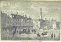
A drawing of Cornhill in the 1830s. The Royal Exchange is on the left.
-
Cornhill from the air
-
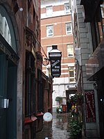
Alley adjacent to St. Michael's
-
Interior of St. Michael's
-
Cornhill in 1630, showing the Royal Exchange and the Water-Conduit, called the Tun
-
Plan showing the extent of the Great Fire in Cornhill in 1748
References
- ^ Ordnance Survey data.
- ^ Timms, John (1855). Curiosities of London, p. 229. David Bogue London. Digital edition from Harvard College library accessed on 2007-11-16.
- ^ Thomson, Richard (1827). The Chronicles of London Bridge, p. 357. Smith Elder and Co, London. Digital edition accessed 2007-11-16.
- ^ "On this spot a well was first made... by Henry Wallis Mayor of London in the year 1282". Goo.gleMaps.
- ^ Winn, Christopher (2007). I Never Knew That About London. Ebury Press. ISBN 978-0-09-191857-6.
- ^ "Men's Marathon". Archived from the original on 30 April 2013. Retrieved 30 May 2015.
- ^ "Women's Marathon". Archived from the original on 2 May 2013. Retrieved 30 May 2015.


5 Annotations
First Reading
Pedro. • Link
Cornhill.
L&M Companion says...
One of the principle streets of the city-"extraordinary publick, pleasant and spacious..and inhabited mostly by rich Traders.The standard near its junction with Leadenhall Street was the mark from which distances to and from London were measured.
Pedro. • Link
For Inhabitants of London in 1638
St. Michael, Cornhill see..
http://www.british-history.ac.uk/…
For Map 1746 see…
http://www.motco.com/Map/81002/Se…
Second Reading
Bill • Link
Cornhill, between the Poultry and Leadenhall Street, an important portion of the greatest thoroughfare in the world, was, says Stow, "so called of a corn market time out of mind there holden." At the beginning of the 14th century and probably long before the corn market was held at Graschirche [Gracechurch], at the east end of Cornhill, and a general market on Cornhill proper. In 1310 a royal proclamation commanded that henceforth no one should presume "to hold a common market for any manner of merchandise . . . after the hour of noon ... in any other place within the City save only upon Cornhulle." The markets in Chepe and elsewhere were to be closed at noon. In course of time the Cornhill market-people presumed too much upon their privilege; and in 1369 the evening market was forbidden to be kept open after sunset.
...
Besides the pillory and the stocks Cornhill had its prison, called the Tun, for street offenders; its conduit "of sweet water," and its standard. The Tun was built in 1282 by Henry de Waleis, Mayor, who built the Stock Market. It was enlarged in 1475 by Sir Robert Drope, Mayor, and its site is at present marked by an unused pump nearly facing No. 30. The conduit adjoining it was first built of stone by Henry de Waleis, but it was re-erected in 1401; and the standard in 1582, for water from the Thames, brought by an artificial forcer invented by Peter Morris, a Dutchman, the first person who conveyed Thames water into houses by pipes of lead. The standard stood near the junction of Cornhill with Leadenhall Street, and was an object of such mark that distances throughout England were measured from it as the heart of the City.
---London, Past and Present. H.B. Wheatley, 1891.
San Diego Sarah • Link
Cornhill seems to have been laid out in medieval times to service the Weigh House with an alley and yard behind.
The Weigh House on Weigh House Yard was the building for the weighing of goods imported into London from overseas. The “King’s Beam” was used here as it was the official standard for weights at the time.
The King’s Beam later moved to Eastcheap.
Although still called Weigh House Yard in John Strype’s survey of 1720, it shows up as Sun Court in John Rocque’s map of 1762 – so evidently the name changed around this time.
The name change to Sun Alley is suggestive of a local pub, as many courts and alleys were named after local inns.
Sun Alley was almost destroyed on 7 November 1765 when a large fire destroyed much of the area and reached right to the very edge of the court, having burnt down all the buildings to the eastern side of Cornhill.
https://www.ianvisits.co.uk/blog/…
Third Reading
San Diego Sarah • Link
By Pepys' time the Standard at Cornhill was frequently used for the London terminus on maps.
No, it wasn't an Inn; it was a well at the convergance of 4 major roads leading north, south, east, and west.
For more on maps and the Standard, see
https://www.pepysdiary.com/encycl…